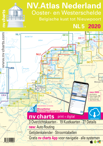
NV.Atlas NL5 - Ooster- & Westerschelde
Description
NV.Atlas Nederland NL 5, Ooster- & Westerschelde
Combination pack paper & digital download incl. App.
Format 30x42cm, bound to Atlas. This chart folio contains a download code for all charts in this area / coverage in the digital nv charts format to be used on a smartphone/tablet with the nv chart app. This app is compatible with Apple: iOS/MacOSX, Android, Windows 7/8/10.
- • Passage Charts
- • Coastal Charts
- • Details
- • Details and harbour plans
- • Digital Charts & Navigationsoftware
- • Tidal data with currents and heights incl. in digital charts
- • Tidal calendar
- • Marina & harbour plans both digital and paper
- • Notices for Navigation in German and dutch language
nv charts for the Netherlands - The charts for the sea area Ooster- & Westerschelde rely on the data from Netherland Hydrographic Office and contain additional marina and harbour plans as well as details for approaches and passages. Bridge heights and opening times are included. The cartography shows the presentation of buoys and marks which is common for the Netherland inland waters. The atlas format allows a clear structure for navigation. Approaches, ports and anchorage are found fast and easily. All nautical information and important details are available in the charts and in the digital version of the app as well. Tidal data is shown in the software and app. The nv charts cartography is famous for its clever design of the coverages for each chart making best possible use of each scale.
Update
The chart folios for the Netherlands from nv charts are published each year an a fresh and revised edition. For the digital nautical charts a download is provided each spring. Note: up-to-date charts are good seamanship and the base for a safe navigation. Nv charts is offering a monthly correction service for charts of the North Sea from April to October. That way all mariners are always up-to-date.
Scales
Passage Charts
C1 Zuidelijke Noordzeekust tot Dover 1 : 375.000C2 Dunkerque tot Oostende 1 : 100.000
C3 Oostende tot Westkapelle 1 : 100.000
Coastal Charts
C4 Westerschelde Monding 1 : 50.000C5A Oosterschelde Monding 1 : 50.000
C5B Westerschelde · Vlissingen tot Braakman 1 : 50.000
C6 Westerschelde · Braakman tot Turfplaten 1 : 50.000
C7 Westerschelde · Turfplaten tot Antwerpen 1 : 30.000
C8 Antwerpen 1 : 30.000
C9A-C Kanaal Gent - Terneuzen 1 : 30.000
C9D Kanaal door Zuid-Beveland 1 : 25.000
C10D Kanaal door Walcheren 1 : 25.000
C11 Veerse Meer West 1 : 20.000
C12 Veerse Meer Oost 1 : 20.000
C13 Oosterschelde West 1 : 45.000
C14 Oosterschelde · Mastgat · Krabbenkreek 1 : 30.000
C15 Oosterschelde Oost 1 : 45.000
C16D Schelde-Rijnverbinding · Zoommeer 1 : 25.000
C17A-B Schelde-Rijnverbinding 1 : 25.000
Details
C10A Zeebrugge 1 : 25.000C10B Blankenberge 1 : 10.000
C10C Zeebrugge 1 : 10.000
C16A Nieuwpoort 1 : 20.000
C16B Oostende 1 : 20.000
C16C Cadzand Bad 1 : 8.000
C18A Oostwatering 1 : 10.000
C18B Kamperland 1 : 10.000
C18C Oranjeplaat 1 : 10.000
C18D Bastiaan de Langeplaat 1 : 10.000
C18E Kortgene · Wolphaartsdijk 1 : 10.000
C18F Zandkeeksluis 1 : 10.000
C18G Veere 1 : 10.000
C18H Middelburg 1 : 10.000
C18J Vlissingen 1 : 10.000
C18K Breskens 1 : 15.000
C19A Burghsluis 1 : 10.000
C19B Colijnsplaat 1 : 10.000
C19C Roompotsluis 1 : 20.000
C19D Zierikzee 1 : 10.000
C19E Goessche Sas 1 : 7.500
C19F Stavenisse 1 : 10.000
C19G Sint Annaland 1 : 7.500
C20A Bruinisse 1 : 15.000
C20B Yerseke 1 : 15.000
C20C Tholen 1 : 10.000