


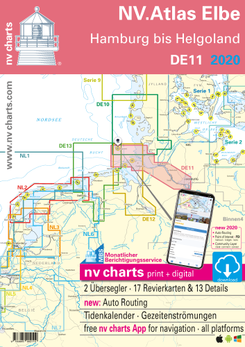

Description
NV.Atlas Elbe DE 11, Island of Helgoland via River Elbe to Hamburg
Combination pack paper & digital download incl. App.
2 Passage Charts, 17 Coastal charts & 13 Details/Plans. Format 30x42cm, bound to Atlas. This chart folio contains a download code for all charts in this area / coverage in the digital nv charts format to be used on a smartphone/tablet with the nv chart app. This app is compatible with Apple: iOS/MacOSX, Android, Windows 7/8/10.
- • 2 Passage Charts
- • 17 Coastal Charts
- • 13 Details
- • Tidal Calendar and Currents included
- • Digital charts for navigation software and nv charts App
- • Harbour plans in paper & digital
- • Notices for Navigation in German and English language
nv charts for the North Sea - The Charts for the sea area "Elbe - Island of Helgoland via River Elbe to Hamburg" are for the use by leisure mariners optimized and professional cartography for the North Sea. All information necessary for the navigation in the challenging waters of the German Bight is provided together with additional harbour plans and details for approaches and passages in these waters. The chart folio also contains tidal data and currents. They are referenced to tidal diamants in the charts.
The atlas format allows a clear structure for navigation. Approaches, ports and anchorage are found fast and easily. All nautical information and important details are available in the charts and in the digital version of the app as well. Tidal data is shown in the software and app. The nv charts cartography is famous for its clever design of the coverages for each chart making best possible use of each scale.
Update
The chart folios for the German North Sea from nv charts are published each year in a fresh and revised edition. For the digital nautical charts a download is provided each spring. Note: up-to-date charts are good seamanship and the base for a safe navigation. NV charts is offering a monthly correction service for charts of the German North Sea from April to October. That way all mariners are always up-to-date.
Scales
Passage Charts
C1 Die Elbe 1 : 375.000C2 Ansteuerung von Elbe und Weser 1 : 150.000
Coastal Charts
C3 Ansteuerung von Helgoland 1 : 50.000C5 Die Elbmündung 1 : 50.000
C6 Scharhörn bis Kugelbake 1 : 50.000
C7 Kugelbake bis Otterndorf 1 : 50.000
C8B Oste 1 : 40.000
C9 Otterndorf bis Brunsbüttel 1 : 30.000
C10 Brunsbüttel bis St. Margarethen 1 : 30.000
C11 St. Margarethen zur Stör 1 : 30.000
C11A Die Stör bis Itzehoe 1 : 30.000
C12 Stör Mündung bis Rhinplate Süd 1 : 30.000
C12A Dornbusch 1 : 30.000
C13 Rhinplate Süd bis Pagensand 1 : 30.000
C13A Die Krückau bis Elmshorn 1 : 30.000
C13B Die Pinnau bis Uetersen 1 : 30.000
C14 Pagensand bis Lühesand 1 : 30.000
C15 Lühesand bis Wedel 1 : 30.000
C16 Wedel bis Teufelsbrück 1 : 30.000
Details
C4 Helgoland 1 : 12.500C8A Cuxhaven 1 : 10.000
C10A Schleusenanlagen Brunsbüttel 1 : 17.500
C12B Hafen von Glückstadt 1 : 10.000
C14A Stadersand 1 : 15.000
C15A Hamburger Yachthafen 1 : 6.000
C15B Schulau 1 : 4.000
C16A Neuenschleuse 1 : 2.500
C16B Mühlenberg 1 : 2.500
C16C Rüschkanal 1 : 8.000
C17 Teufelsbrück bis Köhlbrand 1 : 15.000
C18 Köhlbrand bis Norderelbbrücken 1 : 15.000
C19 Süderelbe 1 : 15.000
Customers also bought
USD 19,80