nv-charts Reg. 9.1, Bahamas North West, Bimini & Berry Islands, Nassau to Abaco, Grand Bahama

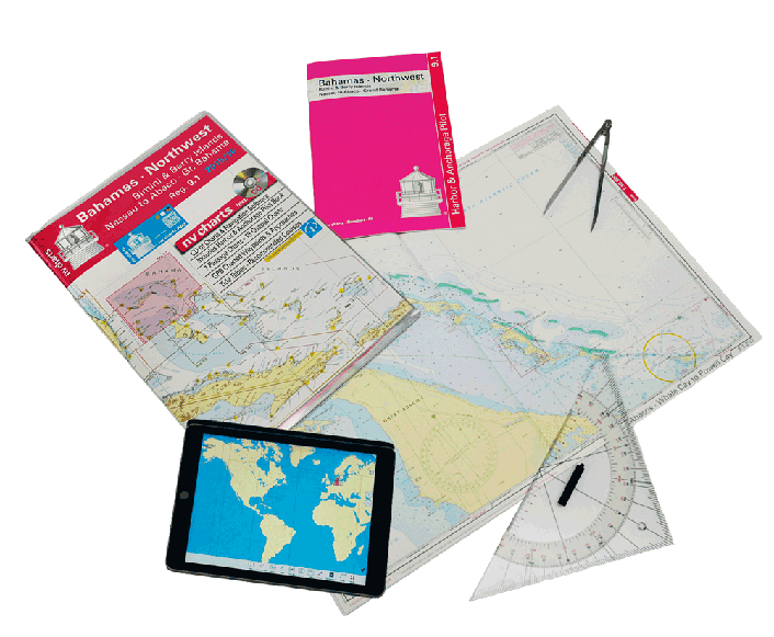

Description
nv-charts Reg. 9.1, Bahamas North West, Bimini & Berry Islands, Nassau to Abaco, Grand Bahama
Format: Kombipack Papier / Digital download and App- • 6 Overview charts
- • 18 Coastal charts & Details
- • Includes Harbour & Anchorage Pilot Bookt
- • GPS Charted Waypoints - Approaches
- • Tide Tables - Recommended Course
- • Pilotbook The nv-charts are characterised by fine contours and easy to distinguish colour graduations of the depth lines – turquoise for coral reefs, red for the 2-meter-line and blue for the 5-m-areas.
Presented in a handy, user friendly size, (23½’’ x 16 ½’’) a thick plastic envelope protects the charts, enabling them to be easily stored.
The importance of good graphical representation of the topography when sailing in the Caribbean is essential.
Well marked rivers, towns and street plans all help to give a clear overall view of the shoreside facilities of the islands. Red numbered waypoints with coordinates based on WGS 84 enable yachtsmen to navigate using their GPS instruments. Heights and depths are given in the internationally accepted format of meters. Large scale approaches and land contour markings simplify the entrance into anchorages.
Maßstäbe
Passage Charts
C0 Caribbean Sea 1: 6,500.000C1 Bahamas Northwest 1: 900,000
C2 Great Bahama Bank (Northern Part) 1: 340,000
C3 Northeast Providence Channel 1: 340,000
C4 Little Bahama Bank (Eastern Part) 1: 340,000
C5 Northwest Providence Channel 1: 340,000
C6 Little Bahama Bank (Western Part) 1: 340,000
Coastal Charts
C7 Bimini Island North 1: 40,000C8 Bimini Island South 1: 40,000
C9 Berry Islands South 1: 40,000
C10 Berry Islands East 1: 40,000
C11 Berry Islands North 1: 40,000
C12 New Providence West 1: 60,000
C13 New Providence East 1: 60,000
C15 Abaco · Little Hbr. to Marsh Hbr. 1: 60,000
C16 Abaco · Marsh Hbr. to Whale Cay 1: 60,000
C17 Abaco · Whale Cay to Powell Cay 1: 60,000
C18 AbacoWhale Cay to Morraine Cay 1: 60,000
C19 Abaco · Allans Cay to Carters Cay 1: 60,000
C20 Abaco · Carters to Double BreastedCay 1: 60,000
C21 Abaco · Double Breasted to WalkersCay 1: 60,000
C22 Grand Bahama Island 1: 60,000
C23 Grand Bahama Island · Freeport 1: 60,000
Detail Charts
C6A Bimini Island Approaches 1: 15,000
C14 Nassau Harbour 1: 15,000
Legend · General Notes p.25
Tide Tables p.26
Harbor & Anchorage Pilot Book attached