NV. Binnenband 3 Nördliche Oder & Peene


Description
NV. Binnenband 3 Nördliche Oder & Peene
Format: Combination pack with paper charts & digital download for appThe following waterways are included in this folio:
• Die Peenewasserstraße
• Die Trebel bis Triebsees
• Die Oder von Ratzdorf bis Hohensaaten
• Die Oder von Hohensaaten bis km 712
• Die Hohensaaten-Friedrichsthaler-Wasserstraße
• Die Westoder von Friedrichsthal bis Gartz
• Die Ost- und Westoder von Gartz bis Szczecin
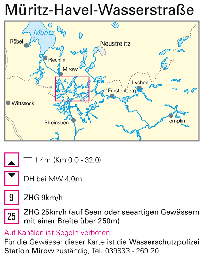
The NV. Chart Atlas Binnen for German Inland Waters are specially designed in full colour for inland navigation and uses a scale of 1:35.000. Chart are produced with the concept "practical in handling and precise in the information". Large scale details and condensed text inform about water depths, height clearances, locks, marinas and other sights. The register and a clear overview chart enable fast and safe work within the atlas. The logic and clear structure makes orientation easy and is supported by printed kilometers on each chart. Dangerous areas are marked in red. The chart folios come in four editions, with seamless conection to each other.
With this combination pack every boater is perfectly equiped for digital navigation! All charts can be downloaded and used in the free-of-charge app nv charts. The app can be used on the following operating systems: iOS, MacOS, Android, Windows 7/8/10. Navigational notes in German language.