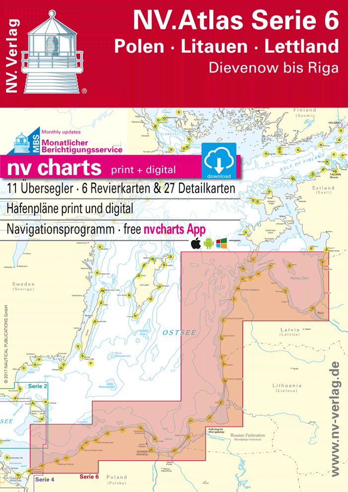
NV. Atlas Serie 6, Polen - Litauen - Lettland

Description
NV. Serie 6, Poland - Lithuania - Latvia
Combination pack paper & digital download incl. App.
11 Passage Charts, 6 Coastal charts & 27 Details/Plans. Format 30x42cm, bound to Atlas. This chart folio contains a download code for all charts in this area / coverage in the digital nv charts format to be used on a smartphone/tablet with the nv chart app. This app is compatible with Apple: iOS/MacOSX, Android, Windows 7/8/10.
- • 11 Passage Charts
- • 6 Coastal Charts
- • 27 Details
- • digitale charts included
- • nv charts app and navigationsoftware
- • Navigational notes in German language
nv charts for the baltic - The clever and compact chart folios are a specially designed cartography for the leisure marine market. All charts for the sea area Poland - Lithuania - Latvia contain nautical charts in various scales, all harbourplans and the details for approaches and passages. Additional shown are overhead clearances for bridges, powerlines, etc. and all nautical and navigational necessary data. The atlas format allows a clear structure for navigation. Approaches, ports and anchorage are found fast and easily. All nautical information and important details are available in the charts and in the digital version for the app as well. The nv charts cartography is famous for its clever design of the coverages for each chart making best possible use of each scale.
Update
The chart folio NV.Atlas Serie 6 for the Baltic Seas from nv charts is published each year in a fresh and revised edition. For the digital nautical charts a download is provided each spring. Note: up-to-date charts are good seamanship and the base for a safe navigation. Nv charts is offering a monthly correction service for charts of the Baltic Sea from April to October. That way all mariners are always up-to-date.
Scales
Passage Charts
S 0 Stockholm - Riga - Helsinki 1 : 250.000S 1 Kolberg to Riga 1 : 1.250.000
S 2 Bay of Gdansk to Gotland 1 : 520.000
S 3 Dievenow to Ustka 1 : 240.000
S 4 Ustka to Hel 1 : 240.000
S 5 Bay of Gdansk 1 : 240.000
S 6 Mys Taran to Sventoji 1 : 240.000
S 7 Sventoji to Uzava 1 : 240.000
S 8 Uzava to Street of Irbes 1 : 240.000
S 9 Street of Irbes to Ruhnu 1 : 240.000
S 10 Bay of Riga 1 : 240.000
Coastal Charts
S 12 Approach to Gdansk 1 : 80.000S 13 Gdansk to Wisla Smiala 1 : 25.000
S 14 Curonia Lagoon 1 : 80.000
S 15/5 Baltijsk 1 : 20.000
S 17/1 Ventspils 1 : 30.000
S 18 Riga 1 : 30.000
Details
S 11/1 Darlowo (Rügenwalde) 1 : 10.000S 11/2 Mrzezyno (Ost - Deep) 1 : 10.000
S 11/3 Kolobrzeg (Kolberg) 1 : 10.000
S 11/4 Ustka (Stolpmünde) 1 : 10.000
S 11/5 Leba 1 : 10.000
S 11/6 Wladyslawowo (Großendorf) 1 : 10.000
S 11/7 Sopot 1 : 10.000
S 11/8 Gdynia (Gdingen) 1 : 5.000
S 11/9 Puck (Putzig) 1 : 5.000
S 11/10 Jastarnia (Heisternest) 1 : 10.000
S 11/11 Kuznica 1 : 12.000
S 11/12 Hel (Hela) 1 : 5.000
S 13A Gdansk City Harbour 1 : 5.000
S 13B Wisla Smiala 1 : 15.000
S 15/1 Liepaja 1 : 15:000
S 15/2 Nida (Nidden) 1 : 5.000
S 15/3 Sventoji 1 : 10.000
S 15/4 Klaipeda Old Castle Hbr. 1 : 5.000
S 16 Klaipeda Harbour 1 : 15.000
S 17/2 Pavilosta (Paulshafen) 1 : 10.000
S 17/3 Kuivizi 1 : 5.000
S 17/4 Ruhnu 1 : 5.000
S 17/5 Roja 1 : 10.000
S 17/6 Mersrags 1 : 10.000
S 17/7 Engure 1 : 5.000
S 17/8 Skulte 1 : 5.000
S 17/9 Salacgriva 1 : 10.000