NV. Serie 2, Lübecker Bucht - Bornholm

Description
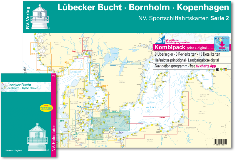
NV. Serie 2, Lübeck Bight - Bornholm - Copenhagen
Combination pack paper & digital download incl. App.
9 Passage Charts, 8 Coastal charts & 15 Details/Plans. This chart folio contains a download code for all charts in this area / coverage in the digital nv charts format to be used on a smartphone/tablet with the nv chart app. This app is compatible with Apple: iOS/MacOSX, Android, Windows 7/8/10.
- • 9 Passage Charts
- • 8 Coastal Charts
- • 15 Details
- • Harbourguide with plans for all marinas and harbours
- • Harbourguide in paper & digital, text in german and english language
- • digitale charts included
- • new: Vectorchart download
- • nv charts app and navigationsoftware
- • Aerial photographs of German and Danish coast in digital format
- • Navigational notes in German language
nv charts for the baltic - The clever and compact chart folios are a specially designed cartography for the leisure marine market. All charts for the sea area Lübeck Bight - Bornholm - Copenhagen contain nautical charts in various scales, all harbourplans and the details for approaches and passages. Additional shown are overhead clearances for bridges, powerlines, etc. and all nautical and navigational necessary data. The atlas format allows a clear structure for navigation. Approaches, ports and anchorage are found fast and easily. All nautical information and important details are available in the charts and in the digital version for the app as well. The nv charts cartography is famous for its clever design of the coverages for each chart making best possible use of each scale.
Update
The chart folio NV.Atlas Serie 2 for the Baltic Seas from nv charts is published each year in a fresh and revised edition. For the digital nautical charts a download is provided each spring. Note: up-to-date charts are good seamanship and the base for a safe navigation. Nv charts is offering a monthly correction service for charts of the Baltic Sea from April to October. That way all mariners are always up-to-date.
Scales
Passage Charts
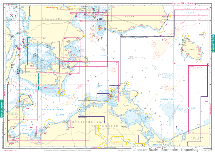
Übersichtskarte Serie 2 1 : 520.000S 15 Mecklenburger Bucht West 1 : 155.000
S 15A Mecklenburger Bucht Ost 1 : 155.000
S 16 Møn Südost 1 : 155.000
S 23 Sund Süd 1 : 140.000
S 24 Møn - Rügen - Ystad 1 : 230.000
S 24A Ystad - Rügen - Bornholm 1 : 230.000
S 25 Bornholm 1 : 140.000
S 25A Hanö Bucht 1 : 260.000
Coastal Charts
S 13 Fehmarn 1 : 80.000S 14 Lübecker Bucht 1 : 80.000
S 17 Smålandsfahrwasser West 1 : 80.000
S 18 Smålandsfahrwasser Ost 1 : 82.000
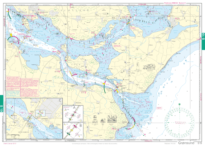
S 19 Grönsund 1 : 60.000
S 19A Guldborg Sund 1 : 60.000
S 20 Fakse Bucht 1 : 60.000
S 21 Sund Mitte 1 : 80.000
Details
S 13A Fehmarnsund 1 : 30.000S 14A Wismar Bucht 1 : 42.000
S 19 Vordingborg 1 : 25.000
S 19A Nykøbing 1 : 30.000
S 22 København 1 : 35.000
S 25 Christiansø 1 : 12.000
S 25B Die Travemündung 1 : 10.000
S 25C Untertrave 1 : 16.500
S 25D Häfen von Rostock 1 : 20.000
S 25D Warnemünde 1 : 10.000