


NV.Atlas NL1 - Borkum naar Oostende
Description
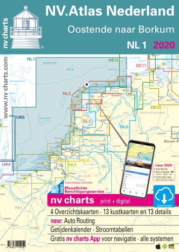
NV.Atlas Nederland NL 1, Ostende naar Borkum\n
Combination pack paper & digital download incl. App.
Format 30x42cm, bound to Atlas. This chart folio contains a download code for all charts in this area / coverage in the digital nv charts format to be used on a smartphone/tablet with the nv chart app. This app is compatible with Apple: iOS/MacOSX, Android, Windows 7/8/10.
- • Passage Charts
- • Coastal Charts
- • Details
- • Details and harbour plans
- • Digital Charts & Navigationsoftware
- • Tidal data with currents and heights incl. in digital charts
- • Tidal calendar
- • Marina & harbour plans both digital and paper
- • Notices for Navigation in German and dutch language
nv charts for the Netherlands - The charts for the sea area from Borkum to Oostende rely on the data from Netherland Hydrographic Office and contain additional marina and harbour plans as well as details for approaches and passages. Bridge heights, opening times and charts for the passage to Amsterdam are included. The cartography shows the presentation of buoys and marks which is common for the Netherland inland waters. The atlas format allows a clear structure for navigation. Approaches, ports and anchorage are found fast and easily. All nautical information and important details are available in the charts and in the digital version of the app as well. Tidal data is shown in the software and app. The nv charts cartography is famous for its clever design of the coverages for each chart making best possible use of each scale.
Update
The chart folios for the Netherlands from nv charts are published each year an a fresh and revised edition. For the digital nautical charts a download is provided each spring. Note: up-to-date charts are good seamanship and the base for a safe navigation. Nv charts is offering a monthly correction service for charts of the North Sea from April to October. That way all mariners are always up-to-date.
Scales
Passage Charts
C1 Oostende tot IJmuiden 1 : 375.000C2 IJmuiden tot Den Helder 1 : 375.000
C3 Den Helder tot Borkum 1 : 375.000
Coastal Charts
C4 Oostende tot Westkapelle 1 : 100.000C5 Westkapelle tot Westhoofd 1 : 100.000
C6 Westhoofd tot Europoort 1 : 100.000
C7 Europoort tot Noordwijk aan Zee 1 : 100.000
C8 Noordwijk aan Zee tot IJmuiden 1 : 100.000
C9 IJmuiden tot Kijkduin 1 : 100.000
C10 Kijkduin tot Vlieland 1 : 100.000
C11 Vlieland tot Terschelling 1 : 100.000
C12 Terschelling tot Het Rif 1 : 100.000
C13 Het Rif tot Borkum 1 : 100.000
C15 Noordzeekanaal · IJmuiden tot Amsterdam 1 : 50.000
Details
C14A Oostende 1 : 15.000C14B Scheveningen 1 : 15.000
C14C Roompotsluis 1 : 20.000
C14D Zeebrugge 1 : 25.000
C14E Blankenberge 1 : 10.000
C14F Zeebrugge · Prins Albertdok 1 : 10.000
C16A IJmuiden 1 : 20.000
C16B Vlissingen 1 : 25.000
C17A Borkum Haven 1 : 15.000
C17B Den Helder 1 : 15.000
C17C West-Terschelling 1 : 10.000
C17D Aanloop West-Terschelling 1 : 30.000
Customers also bought
Similar products can be found here
USD 19,80
USD 19,80